


P&K ODOR
Project Parameter
Product has been archived / Produkt wurde archiviert
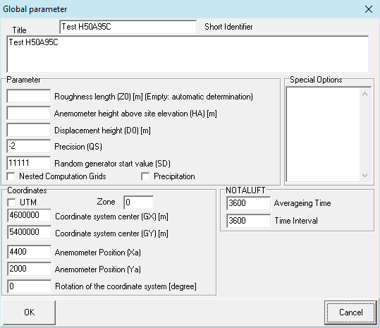
Form for the definition of global project parameters. This form appears in two modes, which makes a simple and extended input possible. Fields, which are not necessary for simple projects, are not present in the simple version.
Title
Arbitrary project title (may be several lines).
Roughness length (Z0) (Empty: automatic determination)
If this parameter is not indicated, then it is computed automatically with the help of the CORINE land register (requires gx and gy within the indicated range). If several sources are defined, first a z0 is computed for each source and afterwards an average z0. The individual values will be weighted with the square of the source height. The computed value is noted in the log file.
The files z0-gk.dmna, z0-gk.dmnt.gz, z0-utm.dmna and z0-utm.dmnt.gz must be present in order to have Z0 automatically determined!
Coordinates system center (GX, GY) [m]
Right and Height, X and Y or Easting and Northing value of the coordinate system's origin.
If Z0 is to be determined automatically, the coordiantes are Gauß-Krüger coordinates or if UTM is checked Universal Transverse Mercator coordinates.
For Gauß-Krüger coordinates the permissible range of values for representation is in the third strip: and .
For UTM coordinates, the calculation raster must be in the 32. strip. Zone can be set as prefix.
If the less-or-equal signs are not visible, it is because the used Browser version does not support these (yet).
Following parameters are to be found only in the extended version of this form.
Short Identifier
Abbreviation of the project (max. 255 characters since Version 2.5). Only this Short Identifier is used in the AUSTAL files for identification.
Random generator start value (SD)
Initial value of the random-number generator (default value 11111). Another sequence of random numbers is generated by choice of another value, so that in the results another sample is represented.
Anemometer height over disturbance height (HA) [m]
Anemometer height above ground (default value 1) is 10 m + d0). If an AK-Term is used, which contains anemometer heights for all roughness classes, then the (to the used z0) corresponding value is used.
In case a new time line in the format AKTERM is used the parameter HA does not need to be set and should not to be set.
Displacement height (D0) [m]
Displacement height of the meteorological profiles (default value 1) 6z0).
Precision (QS)
Quality class for the definition of the emission rate of particles (default value 0). An increase of 1 causes a duplication of the particle number and thus a decrease of the statistical uncertainty (dispersion) around the factor 1/p2. It also doubles computing time. This applies accordingly to a decrease of the value. By default an AKS is calculated with at least 43,000,000 particles, an AKTerm with at least 63,000,000 particles.
Anemometer Position (Xa, Ya)
Coordinates of the anemometer position (default value 0, 0 m). The position of the anemometer must lie within the computing area.
Nested Computation Grids
Nested Computation Grids instead of only one homogeneous grid (see AUSTAL.pdf section 9 and Computation Grids).
Special Options
Other options, as stated in AUSTAL.pdf , can be declared here. Each parameter is to be entered on a separate line. the parameters NESTING and NOSTANDARD are generated automatically.
Rotation of the coordinate system [degree]
See also: Operations within forms
1) empty entry field