


P&K 3781 (VDI 3781 2)
Correction of the stack height
Product has been archived / Produkt wurde archiviert
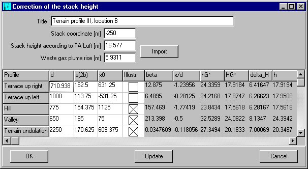
Title
Any text can be entered here. It will appear in the correction report of the corrected stack heights according to VDI 3781.
Stack coordinate [m]
The X-Coordinate of the stack location (in meters) in the system of coordinates which has been put into the terrain section arbitrarily, is to be set as input parameters of the correction here. The modification of the location requires a new fixing (or a new calculation) of the characteristic schema parameter.
Stack height according to TA Luft [m]
The stack height calculated according to TA Luft is to be set in meters as input parameters of the correction. The stack height is available in the program section TA Luft and can be imported from there (import).
Waste gas plume rise [m]
The waste gas plume rise calculated according to VDI 3781 Part 2 is to be set in meters as input parameters of the correction. The plume rise is available in the program section TA Luft and can be imported from there (F5).
Terrace up right, Terrace up left, Hill, Valley, Terrain undulation - d
The characteristic width of the terrain schema is to be entered in meters according to the guideline VDI 3781 Part 2.
Terrace up right, Terrace up left, Hill, Valley, Terrain undulation - a(2b)
The characteristic width of the terrain schema is to be set in meters according to the guideline VDI 3781 Part 2. This equals (with the exception of the terrain undulation) the parameter a from the guideline VDI 3781 Part 2. The parameter 2*b from the guideline is the one for the terrain undulation.
Terrace up right, Terrace up left, Hill, Valley, Terrain undulation - x0
The distance between the origin of the arbitrary system of the coordinates and the center of the terrain schema is to be set in meters. The center of the terrain schema equals the, in the guideline VDI 3781 Part 2, section 3.1 illustrated origins of the system of coordinates referred to the schema.
Illustr.
The inclusion of a schema into the graphic illustration or into the report output can be set here.
beta
Angle of the edge.
x/d
Stack location.
hG*
Corrected effective source height.
HG*
Corrected stack height.
delta_H
Corrected plume rise.
h
Calculation value of the model.